Akron, Ohio’s Innerbelt is a partly abandoned and demolished freeway that was built between 1970 and 1987.
History
Proposal
Conceived by Akron traffic planner Byron Sturm in 1960, 12 the Innerbelt formally proposed in 1962 as part of a larger $43 million, 21½-mile freeway between OH Route 21 in Barberton and OH Route 59 in Kent. 4 5 This initiative aimed to facilitate smooth travel to Akron’s city center. 5 As part of Akron’s larger $17 million Cascade Renewal Project, it intended to stimulate a $100 million investment in downtown infrastructure and businesses. 1 It was also designed to connect the city’s four hospitals to the highway and enable residents to reach any part of the city within a 10-minute drive. 1 2
Governor Michael V. DiSalle expressed support for the project, assuring the state’s eagerness to collaborate in the development of the four-mile freeway that would connect the Akron Expressway from the west and north. 1 Initially, the state offered to finance 75% of the project costs, with the city financing the remainder. 12
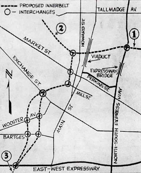
Engineering work on the Innerbelt commenced in 1964, with plans to initiate construction the following year. 2 The proposed plan necessitated the procurement of 1,400 properties, spread across 220 acres. 5 Specifically, the Innerbelt would begin at the Akron Expressway’s northern leg near the Dan Street detention home and the U.S. Naval & Marine training center, go west along the fringe of the hill in the Elizabeth Park area, under the North Main Street viaduct to a North Howard Street interchange just north of North Street and west of Cuyahoga Street. 6 The Innerbelt would then swing south to an intrechange at West Market and Cherry streets and cut due south to the western leg of the Akron Expressway west of Main Street. A freeway from the North Howard Street interchange would connect to Old Portage.
In 1966, the planned route of the Innerbelt south of Cedar Street sparked controversy. 3 The proposed path would bisect the core of the Model Cities neighborhood, extending east of Rhodes Avenue through the Opportunity Park area, potentially uprooting several hundred families. It was also centered through an area that had been redlined, an area that the federal government had labeled undesirable and risky for lenders. 13 Banks often refused to lend to Black homeowners living in redlined areas, whether to buy homes or repair the ones they owned.
Developers and planners opted for the least financially and politically challenging route, often going through neighborhoods predominantly inhabited by communities of color, perceived as less valuable and therefore more cost-effective to demolish. 13 For the Innerbelt, this translated to choosing a route through an area deemed so inferior that it justified almost complete or complete clearance. In most instances, homeowners were compensated only a fraction of their property’s value.
The American Institute of Architects’ urban design assistance team suggested two alternative routes for the Innerbelt. 3 One would divert the Innerbelt north of the Wooster and Rhodes Avenue intersection, while the other would align the freeway along the eastern border of Opportunity Park, connecting to the South High Street and South Main Street interchange of the Akron Expressway’s western leg. These alternatives would negate two years of planning, cost $300,000, and set the project back by three years. 3 13
Construction
Nonetheless, land acquisitions started in 1967, and construction of the Innerbelt’s first phase, between Market and Cedar Streets, commenced in 1970. 5 It opened to motorists on November 10, 1972, costing $19 million to construct. 11
The widespread displacement of black families emerged as a concern for the Akron City Council and mayor. 5 Concurrently, a state cash crunch delayed land acquisitions for the Innerbelt’s second phase, between Cedar and Thornton Streets. In 1975, the only completed section of the expressway served as the location for the Akron Sesquicentennial Fair where more than 10,000 visitors strolled along the roadway where more than 245 industrial and civic displays stretched for more than a mile. 5 8
Ground was broken on October 30, 1975, 7 for the second phase of the Innerbelt, extending from Cedar to Thornton streets. 5 The John G. Ruhlin Construction Company performed $3.8 million worth of preliminary work which included grading, draining, and construction of most of the cross streets connecting with the freeway. 7 A $19 million paving contract was awarded in 1979. It was subsequently opened to traffic on November 25, 1980. 10
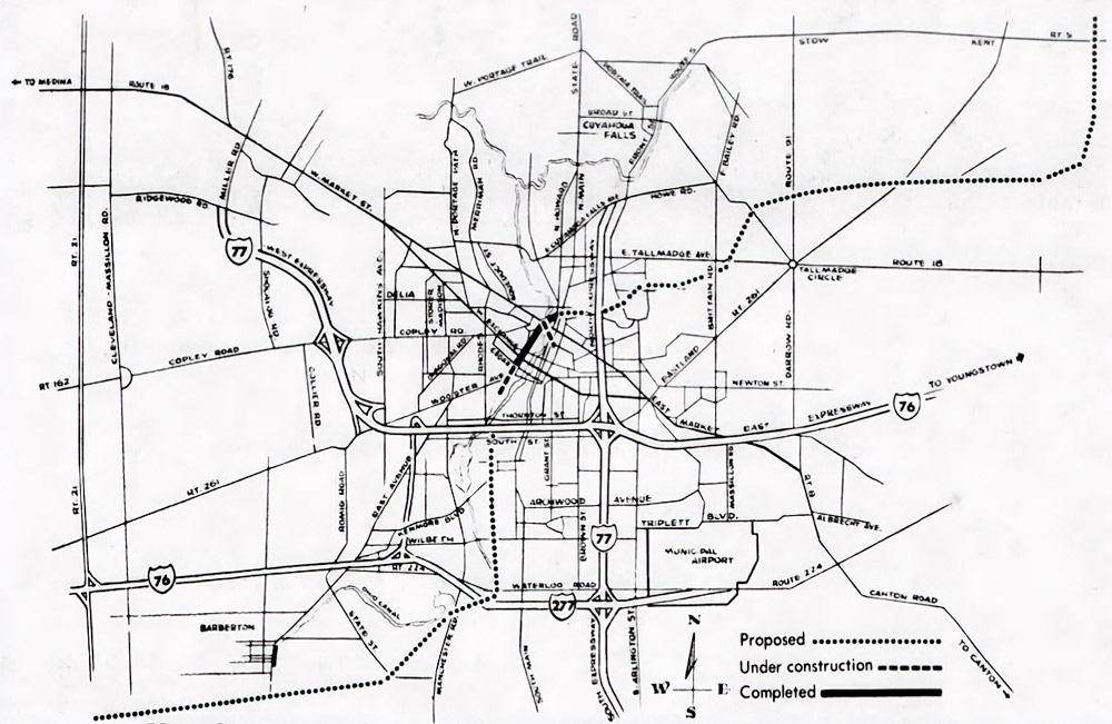
The completion of the first two phases came at a substantial cost of $43 million 9 and resulted in the demolition of 1,000 to 1,500 homes. 4 10 Despite its completion, the four- and six-lane freeway was underutilized as the connections to the north and south were not fully developed. To facilitate connectivity, Perkins Street was expanded in 1981 to link the Innerbelt to OH Route 8, as opposed to constructing a freeway between Market Street, and Akron Expressway/OH Route 8. 9
In 1980, due to financial constraints, the state determined it could not afford to complete the freeway. 4 It was estimated that finishing the northern segment of the Innerbelt would cost $40 million to $66.5 million. 9 10 As a result, only two segments of the initially proposed freeway were finished: the stretch from Market to Thornton Streets and the section surrounding Kent from OH Route 59 to OH Route 43. 4
In November 1984, construction commenced on the final segment of the Innerbelt, connecting Thornton Street to the Akron Expressway’s western leg, now known as Interstates 76 and 77. 4 This $25 million venture enabled eastbound drivers on the Akron Expressway to access the Innerbelt and those traveling south on the Innerbelt to head west on the Akron Expressway. Although additional ramps were initially considered, they were eventually abandoned due to the high costs involved and the limited number of drivers who would benefit from them.
In 1987, the ramps to Interstates 76 and 77 were inaugurated, marking the completion of the Innerbelt’s at a total expenditure of $65 million. 5
Partial Closure
Although the Innerbelt connected to Interstates 76 and 77, it only saw an average daily traffic of 18,000 vehicles, a fraction of its 120,000 vehicles capacity. 5 12 It also only saved commuters an average of 1.25 minutes versus already-existing routes. 12 Moreover, its northern terminus became a hotspot for accidents due to a sudden change from a freeway to a surface street with traffic signals. 5
The construction of the freeway failed to ignite the anticipated revitalization of the city center. Despite the interconnection between the Cascade development and the Innerbelt during the 1970s, retailers predominantly relocated to suburban shopping precincts. 12 Although the creation of new office spaces partially compensated for the downturn in retail, it was insufficient to counterbalance the deterioration of nearby residential areas. The Innerbelt led to an exodus of both black and white inhabitants from its surrounding regions.
In 1999, Mayor Don Plusquellic suggested the demolition of the underutilized Innerbelt, initiating a critical dialogue about the highway’s fate. 5 Although there was no funding at the time, it set the stage for future actions. In 2014, the city revealed a more modest plan to upgrade Dart and Rand avenues, one-way streets that run parallel to the Innerbelt, and shut down the freeway between Exchange and Market Streets. 5 12 It proposed opening the land up for new development.
The $12.7 million project to decommission part of the Innerbelt began in March 2016. 5 In September 2017, the state relinquished control of the northern portion of the Innerbelt to the city, 13 which was closed to traffic that November 2017. 5
Gallery


Sources
- “Promises State Aid for Akron’s Innerbelt Loop.” Newark Advocate, 30 Aug. 1962, p. 29.
- Giles, Robert. “Downtown Link to Xway Listed.” Akron Beacon Journal, 25 Jul. 1962, p. 35.
- Bandy, Don, and Charles Buffum. “Innerbelt at Crossroads: Will Detour Be Necessary?” Akron Beacon Journal, 26 Jan. 1970, p. B1.
- Reiff, Rick. “Innerbelt link to I-76 upcoming.” Akron Beacon Journal, 11 Apr. 1983, p. A8.
- Warsmith, Stephanie, and Cheryl Powell. “City Ramps Up for Builders.” Akron Beacon Journal, 31 Dec. 2014, pp. A1-A6.
- Giles, Robert. “Citizens’ Group Gets ‘Preview’ Of Innerbelt.” Akron Beacon Journal, 24 Jan. 1963, p. 33.
- “Ground broken for innerbelt.” Akron Beacon Journal, 31 Oct. 1975, p. 20.
- Lally, Charles. “Downtown is ‘jam session’ at Sesqui.” Akron Beacon Journal, 5 Jul. 1975, pp. A1-A9.
- Hershey, William. “End of Innerbelt not yet in sight.” Akron Beacon Journal, 20 Mar. 1978, pp. A1-A4.
- “Second section of Akron Innerbelt is opened.” Akron Beacon Journal, 25 Nov. 1980, p. D1.
- “The Belt Is Open.” Akron Beacon Journal, 10 Nov. 1972, p. 10.
- Harper, John. “The demise of Akron’s Innerbelt: planned as a savior, quickly labeled a failure.” cleveland.com, 25 Dec. 2014.
- Bayram, Seyma. “The failed Akron Innerbelt drove decades of racial inequity. Can the damage be repaired?” Akron Beacon Journal, 3 Feb. 2022.