From eastern Ohio into West Virginia and Pennsylvania, the National Road still survives in fragments: old alignments through small towns, stone S bridges over creeks, early arches, and river crossings that once carried the nation’s first great westward traffic. Following the route today reveals not a continuous historic road, but a chain of places where the history of Zane’s Trace, the National Road, and later U.S. Route 40 can still be read in the landscape.
Before the National Road crossed eastern Ohio, the region had already been opened by Zane’s Trace, the earlier frontier route authorized by Congress in 1796 and laid out under the direction of Ebenezer Zane. Running from Wheeling through places such as Zanesville and Chillicothe before reaching Limestone, Kentucky, the trace began as little more than a bridle path but quickly became one of the first important overland routes into the Ohio country. As settlement increased after Ohio achieved statehood, sections of the trace were improved and more heavily traveled, serving migration, trade, and communication across the young state.
The National Road followed as a more ambitious federal improvement. Authorized by Thomas Jefferson on March 26, 1806, it began at Cumberland, Maryland, and reached Wheeling in 1818 after that city prevailed over Steubenville in the competition to secure the Ohio River crossing. Congress approved its westward extension in 1820, and construction in Ohio began in earnest at St. Clairsville on July 4, 1825. Although the new road inherited a corridor already opened by Zane’s Trace, it did not simply duplicate it. Zane’s Trace often kept to the highest ground, while the National Road adopted a broader, more engineered alignment designed to handle stagecoaches, freight wagons, drovers, mail, and migrants moving west.
The road reached Zanesville in 1830 and Columbus in 1833. Inns, villages, and service points developed along it, tollgates were established at regular intervals, and the route quickly became one of the great overland arteries of the early republic. In time, however, the road was altered by later transportation improvements. Segments were widened, straightened, bypassed, or absorbed into U.S. Route 40 after 1926, while still later construction of Interstate 70 left parts of the old alignment isolated or nearly erased. Even so, substantial fragments of the National Road survived, especially in the bridges, towns, and roadside landmarks that continued to mark its path.
Ohio
In eastern Ohio, the National Road still revealed how an early federal highway reshaped older settlements and, later, how they adapted, sometimes uneasily, to modern traffic.


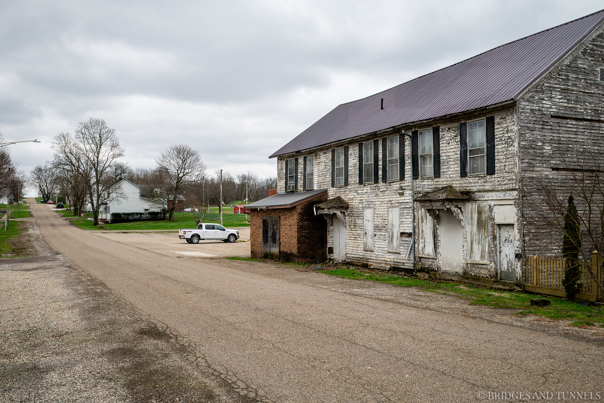
At Old Washington, the route was shifted south of town in 1932, and Interstate 70 later bypassed the community in 1965. Originally platted as New Washington in 1805 along Zane’s Trace, the town grew rapidly after the National Road followed the earlier corridor and reached its peak around 1850. Although diminished, it still retained visible traces of that era in its inns, residences, and surviving stretch of original alignment.


Although Old Washington has seen better days, its historic character remains visible. Several notable buildings have been restored, including the former Colonial Inn, and the town retains a number of handsome residences in the Italianate and Federal styles. Other structures, however, remain vacant or in disrepair, leaving the village with a mix of preserved architecture and visible decline.
Other Ohio segments told a similar story of alteration and survival. At Hendrysburg, the road was realigned in 1935, widened to four lanes in 1947, and partly bypassed by Interstate 70 in 1966.


Founded in 1828, Hendrysburg is a small community known for being the birthplace of William Boyd, the actor best known for portraying Hopalong Cassidy in film and television westerns.


The Stillwater Creek crossing underwent much the same progression: improved in 1935, widened in 1956, and bypassed only a decade later. These changes reflected the broader fate of the National Road in Ohio: an early-19th-century route repeatedly modified to meet twentieth-century demands.


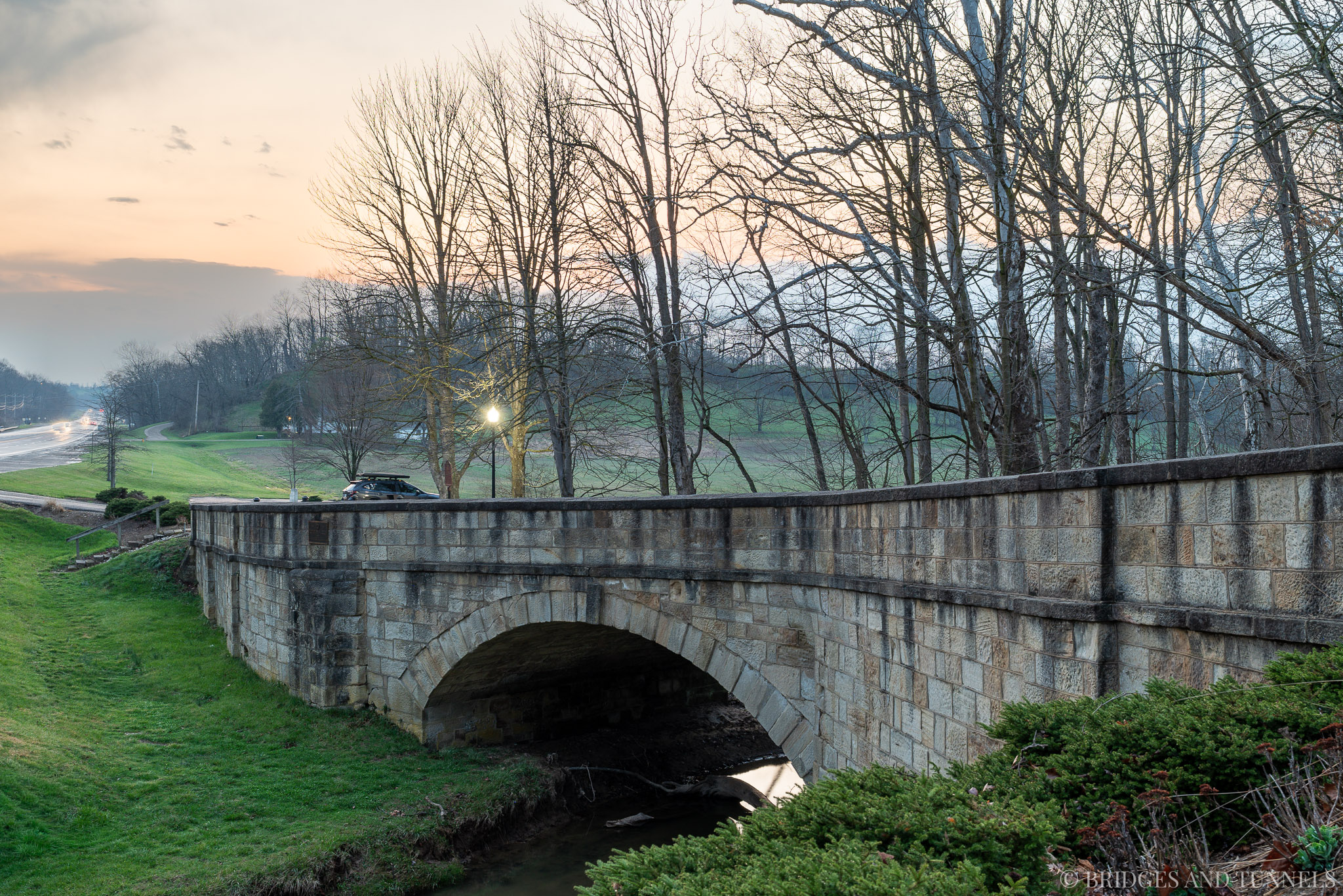
Among the most distinctive Ohio survivals were the masonry S bridges and related stone arches built to carry the road across creeks and ravines. Their reverse curves were not ornamental but practical. They eased the approaches, reduced the arch length required where the crossing was not perfectly square, and helped protect the embankments from erosion. The durability of the design was remarkable, and several remained in service for more than a century after construction.
Preservation came late. By the mid-1930s, many of Ohio’s old stone spans had already disappeared or were threatened, and it was only after organized advocacy, especially from the Daughters of the American Revolution, that the surviving bridges began to be treated as historic landmarks rather than obsolete roadwork. In 1936, the DAR secured permission to mark three of the last remaining National Road S bridges with commemorative plaques at Fox Creek S Bridge, Peters Creek S Bridge, and the Salt Fork S Bridge near Cambridge. Even then, the campaign came too late for some of the road’s most unusual crossings. A three-span arch east of Zanesville had already been removed in 1922.


And another arch at Middlebourne was replaced by concrete in 1939.


The most famous loss was the so-called Crooked Bridge at Hendrysburg in Belmont County, which was buried beneath 20 feet of fill in 1935. Completed in 1826, it was among the strangest and best-remembered of the National Road’s S bridges. According to the old War Department contract, the bridge was built by John McCartney, an Irish stonemason and proprietor of the McCartney Inn, from plans prepared by Benjamin Latrobe. The contract called for 735 perches of Gothic culvert and wall work, 300 perches of bridge work, and a 12-foot chord arch for $1,875. What emerged was an extraordinary structure: 90 feet long, with fifteen distinct curves in its side walls, the north wall measuring 203 feet, and the south wall at 226 feet. Its remarkable alignment made it one of the crookedest and most memorable bridges on the route, and it was the last of the Ohio S bridges to be abandoned.
When efforts first arose to straighten or replace the Hendrysburg bridge, local feeling ran strong enough that former postmaster J. M. Burson was encouraged to answer with verse. In his poem “A Threnody,” he cast the bridge not simply as a piece of stonework but as a witness to western migration, war, and memory, writing of “a million pioneers” crossing on “empire’s westward march.”
Ay, tear ita graceful curvings down!
A century long they’ve stood
while half a nation’s manhood pride
Has crossed above the flood.Along the broad macadam track
spread o’er its rugged arch,
A million pioneers have treked
On empire’s westward march.The swaying cart, the stately coach
Its curves passed day by day,
And pressed to sunset promise o’er
Columbia’s Appian way.A sturdy pioneering band
From ocean’s Orient,
slow plodded through its winding span
Toward westering Occident.In furthering years when war’s alarms
Pealed out a thousand calls,
In answering hosts the boys in blue
Marched through its wave-line walls.And when our battle van was flung
Beyond the ocean brine,
The khakl boys from western plains
Crossed o’er it, line on line.Oh landmark old! Must then it go?
A tear unbidden starts!
A thousand precious memories
Enshrine it in our hearts!Yes, in this mad, unholy hour
Of mammon’s soulless greed,
Ita needs must fall a sacrifice
The jugsernauls of speed!Oh, better that its ponderous bulk
Should sluk into the wave!
Proud decades has it spanned the gulf;
Be now that gulf its grave!
Later, when the bridge again faced replacement, he returned with another appeal: “Waid-man, spare that bridge, / Touch not a single curve.” The poems could not save the structure forever, but they did help crystallize the growing belief that these bridges belonged to the history of the road as much as to its engineering.
“Waid-man” spare that bridge,
Touch not a single curve,
It served a hundred years;
A century more it will serve,
Our fathers reared it there;
A mighty gorge it spanned;
Time’s storms it has defied,
So “Waid-man,” let it stand.
Mary A. Stone of Cambridge soon added a more formal preservation effort through the DAR, helping lead to the placement of the 1936 markers.
Several important Ohio bridges nevertheless survived. The Fox Creek S Bridge, just west of New Concord, carried U.S. Route 40 over Fox Creek. Measuring about 140 feet long and 26 feet wide, it was built with a 30-foot stone arch, cut-stone walls and vault, and a brick floor. During World War I, the bridge was among the last sections of the National Road to be paved with brick for military traffic, with the work completed in 1919. In 1936, the Ohio Chapter of the DAR helped persuade the Ohio Highway Department to reroute traffic around the bridge rather than replace it.


The Peters Creek S Bridge, between New Concord and Cambridge, is also dated to 1828. It measured about 130 feet long and 26 feet wide and crossed Peters Creek near an older Zane’s Trace crossing from 1803, where logs had been used a few hundred yards to the north. The bridge was bypassed by a new U.S. Route 40 alignment in 1932 and preserved after DAR advocacy in 1936. After severe deterioration and flood damage in 2005, it underwent a major rehabilitation in 2007, with much of the structure removed, rebuilt, and strengthened while retaining the historic crossing.


The Crooked Creek Arch Bridge in Cambridge carried the National Road over Crooked Creek near an earlier Zane’s Trace crossing. Built by Kinkeade & Beck in 1825, it used the same cut-stone construction and brick floor found on the other National Road S bridges. In 1939, U.S. Route 40 was placed on a new alignment, and the old bridge was adapted for county road use.


East of Cambridge, the Bell Run Creek S Bridge was another 1828 National Road crossing built by Kinkeade & Beck. It stood near an 1803 Zane’s Trace crossing, where Bell Run Creek had likely been crossed by a ford or log span. Like Fox Creek and Peters Creek, it was bricked during World War I, with that work completed in 1919, and was bypassed by a new U.S. Route 40 alignment in 1932. The DAR also helped secure its preservation in 1936, though it appears to have received less memorialization and long-term upkeep than some of the other surviving bridges.


Near Old Washington is the Salt Fork S Bridge that was also built in 1828. It was bypassed in 1932. The DAR also helped secure its preservation in 1936.


Farther east in Belmont County, related National Road stone arch bridges survived at Barkcamp Creek and Lloydsville, where a bridge crossed a tributary of Wheeling Creek. Both were restored in 2015.


The most imposing Ohio survivor was the Blaine Hill S Bridge at Blaine. Built in 1826 by James Lloyd and Robert Wilson of Hagerstown, Maryland, it was the oldest sandstone bridge in Ohio, the last S bridge completed on the National Road, and the longest of its kind. Increasing traffic led to the bridge’s replacement with the Blaine Hill Viaduct in 1933, though the old bridge remained open to motorists until 1994. After later facing possible demolition, it was spared, reconstructed beginning in 2000, and designated Ohio’s Official Bicentennial Bridge in 2003.


West Virginia
From eastern Ohio, the National Road entered Wheeling, where the route took on a more urban and monumental character. Here, the road encountered one of its most significant crossings, the Wheeling Suspension Bridge over the Ohio River between Wheeling Island and downtown. Completed in 1849, it was the first major suspension bridge in the United States and gave the National Road a fixed river crossing at a time when such structures were still rare and technically ambitious. After the original span collapsed in 1854, a replacement opened in 1859 and was later strengthened, including work associated with Washington A. Roebling in the 1870s. Closed to vehicles in 2019, it remained open to pedestrians and stood as one of the great transportation landmarks of the early American republic.


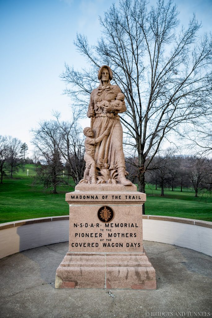
Wheeling also preserved the commemorative landscape that later grew up around the old road. Adjacent to Wheeling Park stood one of the twelve Madonna of the Trail monuments commissioned by the National Society of the Daughters of the American Revolution (DAR) for the National Old Trails Road. Dedicated on July 7, 1928, before an estimated crowd of 5,000, the monument linked the National Road to a broader memory of westward migration and the pioneer experience. Like the road itself, it served both as a marker of movement across the landscape and as a symbol of the nation’s expansion.
Just east of the monument, the Monument Place Bridge in Elm Grove provided another tangible link to the earliest period of National Road construction. Built in 1817 of locally quarried sandstone by Col. Moses Shepherd, it was the oldest bridge in West Virginia and predated the state itself by decades. Over time it was reinforced, widened, veneered in concrete, and listed on the National Register of Historic Places in 1981. Its recent rehabilitation continued that long history of adaptation, preserving the underlying arch while renewing its structure for continued survival. Together, the suspension bridge, the Madonna of the Trail, and the Monument Place Bridge gave Wheeling one of the richest concentrations of National Road history anywhere along the route.


Pennsylvania
Crossing into Pennsylvania, the National Road entered another landscape shaped by both early masonry construction and later transportation change. In Washington County, the route crossed Buffalo Creek near Taylorstown on Pennsylvania’s only S bridge. Built in 1818 and distinguished by its twin stone arches, the Buffalo Creek S Bridge was bypassed when U.S. Route 40 was realigned in 1929, a change that removed its western approach. Even in altered form, it remained one of the clearest reminders that the National Road’s unusual S-bridge design extended beyond Ohio.


Farther east at Beallsville, another Madonna of the Trail monument marked the road’s later commemorative history. Dedicated in December 1928 and restored in 1990 by the DAR, it echoed the Wheeling monument and underscored that the National Road was remembered not only as a highway of commerce and migration but also as a symbolic route of national expansion. These monuments added a twentieth-century interpretive layer to a road whose physical fabric dated back more than a century earlier.


At Brownsville, the National Road encountered one of its most important river crossings at the Monongahela. Before a permanent bridge was established, travelers crossed Dunlap’s Creek and relied on ferries to continue west or east across the river. By 1833, increasing traffic prompted the Monongahela Bridge Company to complete a three-span covered bridge, which served until 1910, when federal navigation requirements necessitated its removal. The replacement Brownsville Bridge, dedicated in October 1914, was built as a toll-free crossing with a substantial main span and accommodations for streetcar service that never materialized. Even after a northern bypass opened in 1962, it remained a key crossing and continued to absorb repairs and modifications as conditions changed.


A short distance away, the Dunlap Creek Bridge carried the National Road across the narrow section of Brownsville known as The Neck. Completed in 1839 by the U.S. Army Corps of Engineers, it is recognized as the first cast-iron metal arch bridge in the United States. Altered in 1922 and later bypassed by newer highway construction, it nevertheless remained one of the most significant engineering survivals on the route. Recent preservation work has sought to restore its historic appearance while stabilizing the structure for the future.


Taken together, Pennsylvania’s surviving National Road landmarks showed the same pattern seen farther west of early ambition, alteration, and preservation. From the various S and arch bridges to the monuments at Beallsville and Wheeling, the old road remains legible not as a continuous, untouched highway but as a chain of places where its history can still be read.
Sources:
- Schneider, Norris F. “Railways Almost Killed National Road But It Came Back Strong, Thanks to Auto.” Sunday Times Signal, 7 May 1944, p. 12-2.
- “Historical.” Cambridge Jeffersonian, 29 Dec. 1904, p. 3.
- Schneider, Norris F. “Three S Bridges Still Standing; Built In 1820s On National Road.” The Times Recorder, 6 Sept. 1964, p. 12.
A nice overview with a great collection of photos.
Fantastic work!
thanks for these lovely photos! I’ve always wanted to go on an extended road trip with my Dad, travel the National Road, Route 66, etc. see all the small towns and things lost to time. maybe someday. the way things are going I guess I could always walk these routes after the total complete collapse of America lol!