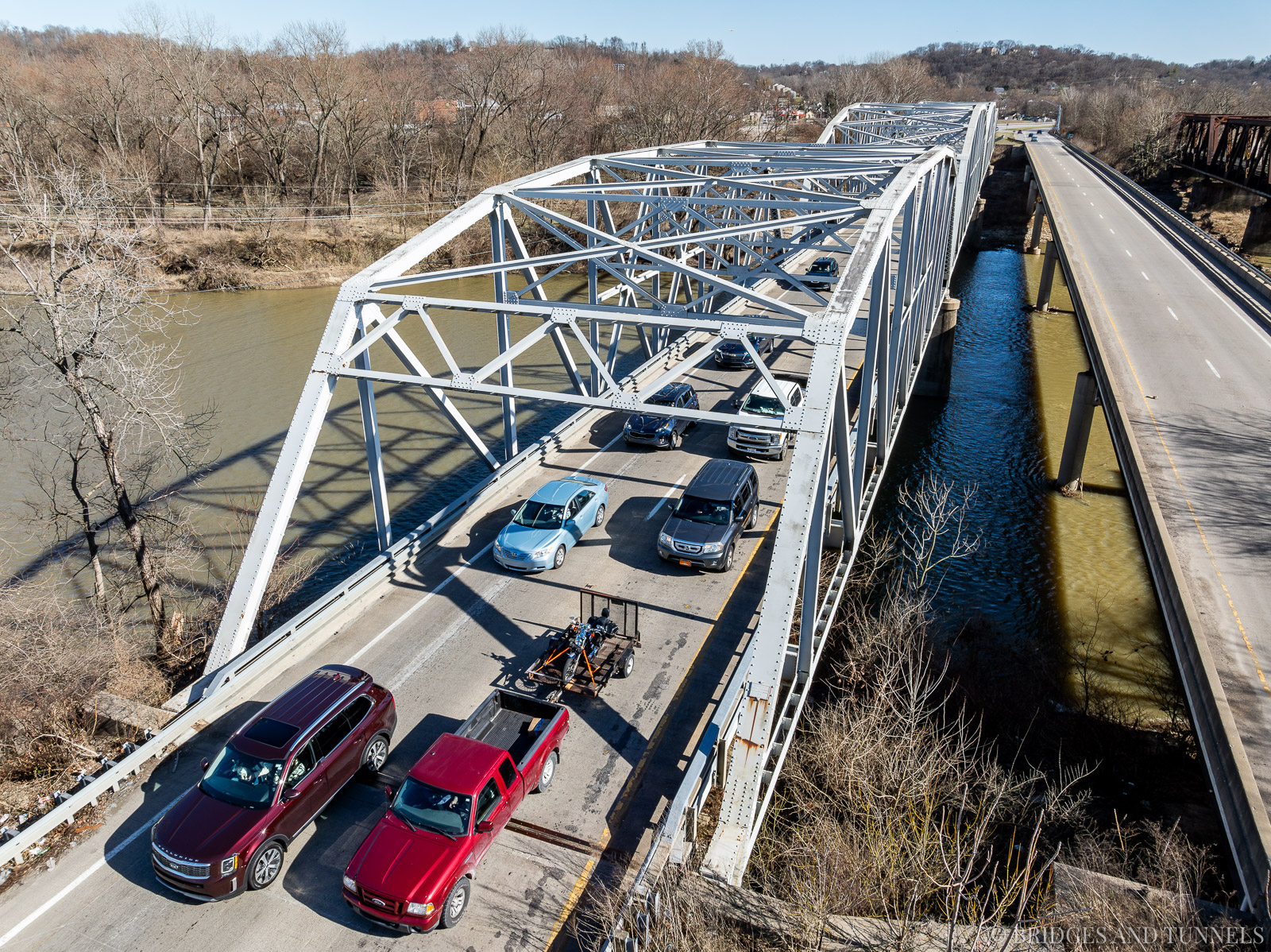
The Cleves Bridge is a Parker through truss bridge that spans the Great Miami River along U.S. Route 50 in Cleves, Ohio.
The Cleves Bridge is a Parker through truss bridge that spans the Great Miami River along U.S. Route 50 in Cleves, Ohio.
History
As early as 1820, dirt roads connected southwest Hamilton County with eastern Indiana and Cincinnati. 10 Several attempts were made to build a road along the Ohio River, but crossing the Great Miami River remained challenging. A small ferry operated at the confluence of the Ohio and Great Miami rivers. However, a more reliable crossing was later established near Cleves, providing a direct route between Cincinnati and Lawrenceburg, Indiana.
By 1834, a ferry service operated at Cleves, carrying passengers and wagons across the river. 10 This was later replaced by a wooden truss bridge, funded by the privately owned Cleves Bridge Company. The company sold shares at $50 each to finance construction and maintenance. The bridge functioned as a toll bridge, charging fees based on the type of transportation used. Shareholders of the company were exempt from tolls.
In 1870, the Cleves Bridge Company sold the bridge to the Hamilton County Commissioners due to declining revenue and the need for maintenance. 10
A flood in 1883 destroyed the Cleves Bridge. 10 Severe erosion and a shift in the river’s course required the bridge to be relocated. It was rebuilt just north of the Indianapolis, Cincinnati & Louisville Railroad, where it was more stable and less susceptible to embankment erosion.
In 1912, the route that would later become U.S. Route 50 was designated as Main Market Route 45. It was reclassified as State Route 7 in 1923 before being redesignated as U.S. Route 50 in 1926.
Another devastating flood in March 1913 washed out the Cleves Bridge, along with every bridge south of Dayton. 5 7 10 In response, the Hamilton County Commissioners sought to replace the bridge. On August 30, bids were received from six bridge companies: 6 10
- Penn Bridge Company, $84,803
- Capital Construction Company, $95,000
- King Bridge Company, $97,000
- Massillon Bridge Company, $110,000
- Bracket Construction Company, $126,000
- Central States Bridge Company, $140,000
The contract was awarded to the Penn Bridge Company, which had the lowest bid and a solid reputation, despite its bid being nearly $60,000 below the highest bidder and $110,000 below the county’s estimate. 6 8 10 The substructure was awarded separately, bringing the total cost of the new bridge to $154,171.
On September 4, the county commissioners awarded the substructure contract to Cleary-White Construction Company of Chicago, despite a dispute with C.H. Glandorf, which contested Cleary-White’s bid over cost concerns. 4 An investigation found falsifications in Glandorf’s excavation and concrete pricing.
During construction, a temporary bridge was used. 9
The new bridge, completed in 1914, was a four-span Parker and Pennsylvania through truss with an overall length of 882 feet. 10 It featured two approach spans of 191 feet and two main spans of 250 feet. The bridge deck initially accommodated a rail track used by the Cincinnati, Lawrenceburg & Aurora interurban railway, which was removed in 1931 after the railway ceased operations. A new concrete deck, railings, and expansion joints were installed at that time.
In 1951, all bearing devices were replaced, and the original concrete sidewalk was replaced with steel plating. 10 The concrete deck was overlaid with an asphaltic surface. In 1976, the steel diagonals were replaced, vertical hangers were reinforced, and lateral rods were cleaned and tightened. The entire bridge was repainted. The bridge was repainted using epoxy paint in 1981, and in 1985, the bridge deck was patched and resurfaced with asphaltic concrete. The abutments and piers were also repaired.
Second Bridge
By the mid-1950s, proposals were made to eliminate a sharp curve at the eastern approach to the bridge. 1 However, the project was delayed due to the Ohio Department of Highways’ plan to construct a four-lane expressway from the Indiana state line to Cincinnati, bypassing Cleves, North Bend, and Addyston. 3
Construction bids were opened for a $4.5 million expressway project in June 1958. 3 Local communities opposed resurfacing the existing route and retaining an overpass for Harrison Avenue in North Bend. The state ultimately built an overpass at Briar Road instead.
The westbound bridge for U.S. Route 50, constructed by the American Bridge Division of United States Steel, opened in July 1960. 2 The original 1914 bridge was retained for eastbound traffic.
Replacement
In February 1988, an inspection by the Ohio Department of Transportation uncovered severe structural deterioration of the lower chords. 11 A follow-up examination the following February revealed that one of the four eyebars in the lower chord member had fractured. 10 The bridge was immediately closed, and traffic was redirected to the 1960 span.
Balke Engineers was hired to assess structural deterioration, and H.C. Nutting Company conducted ultrasonic testing on the bridge’s pins. 10 Over 70% of the tested pins exhibited internal flaws. Additional evaluations found severe corrosion, significantly reducing the bridge’s load capacity.
ODOT stated that a replacement bridge for the 1914 structure may not be ready until 1995. 11 But after an intense grassroots campaign to have a new bridge built sooner, ODOT announced that the redecking would begin later in the year, construction of a new bridge would begin when that was finished, and it would be completed in 1992.
A replacement bridge, a standard steel girder structure, was completed on October 31, 1992. 12
Gallery


Historic
Courtesy of the Fred Mitchell for the Historic American Engineering Record, HAER No. OH-70, January 1990.


Details
- State: Ohio
- Route: US Route 50
- Status: Active (Automobile)
- Type: Parker Through Truss
- Total Length: 882' (1914)l 893' (1960)
- Main Span Length: 250' (1914); 248' (1960)
- Spans: 191'; 250'×2; 191' (1914)
- Deck Width: 28.6' (1914); 32.2' (1960)
- Roadway Width: 26.11' (1914)
- Height of Structure: 46' (1914)
- Horizontal Navigational Clearance:
Sources
- Feldman, James. “Death Waits for Autoists at Cleves Curve on Route 50.” Cincinnati Post, 1 Jan. 1955, p. 4.
- “A New Bridge.” Cincinnati Enquirer, 9 May 1960, p. 8D.
- “Road Officials See Little Delay in Relocation Job on U.S. 50.” Cincinnati Enquirer, 10 Apr. 1958, p. 30.
- “Reject.” Cincinnati Enquirer, 5 Sept. 1913, p. 14.
- “Send Help!” Cincinnati Enquirer, 27 Mar. 1913, p. 5.
- “Notice to Contractors.” Cincinnati Enquirer, 10 Jul. 1913, p. 10.
- “Damage.” Cincinnati Enquirer, 24 Jun. 1913, p. 11.
- “Bids.” Cincinnati Enquirer, 30 Aug. 1913, p. 15.
- “High Waters.” Cincinnati Enquirer, 1 Apr. 1914, p. 8.
- Mitchell, Fred. “Cleves Bridge.” Historic American Engineering Record, Jan. 1990.
- Markwalter, Bob. “A lesson in grassroots political pressure.” Journal-Press, 11 Apr. 1989, pp. 1A-2A.
- “Barrel zones.” Cincinnati Enquirer, 21 Jun. 1991, p. 1 Extra.